Grant Rawson is a CIMAS Senior Research Associate with AOML’s Physical Oceanography Division. He is involved with all the projects.
CIMAS Researchers James Hooper, Grant Rawson, and Christian Saiz recently returned from a 18 day research cruise aboard the UNOLS research ship R/V Endeavor in support of the MOCHA/WBTS project. The MOCHA (Meridional Overturning Circulation and Heat Array)/WBTS (Western Boundary Time Series) project at the University of Miami is a collaborative project with NOAA/AOML Physical Oceanography Division to measure the meridional (north-south) overturning circulation and ocean heat transport in the North Atlantic Ocean.
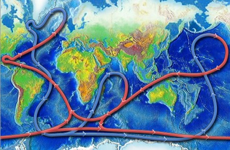
These transports are associated with the thermohaline circulation, the process of warm waters moving poleward at the surface of the ocean, then cooling and sinking, and returning towards the equator in the deep ocean. This colder, denser water sinking is what drives the thermohaline circulation and starts the “global conveyor belt” of water, a connected system of deep and surface currents that circulate the global on a 1,000-year time span. This global system is a crucial part of the Earth’s climate system and the ocean nutrient and carbon dioxide cycles.
The global ocean conveyer belt. Image from NOAA's National Ocean Service.
Ocean circulation
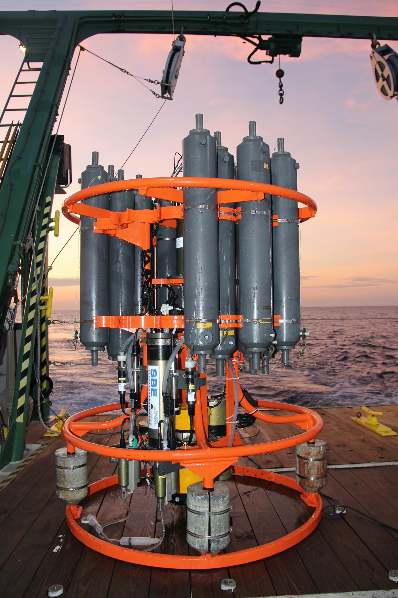
One of the primary ways we study ocean circulation and the related seawater properties is through direct measurements made from ships using something called a “CTD.” A CTD (Conductivity, Temperature, Depth) package is a special set of sensors lowered to the sea floor, over 5000m below the surface, using a large shipboard winch and cable. The CTD package consists of several different sensors to measure different water properties, including salinity, temperature, oxygen, pressure, and current velocity.
CTD (Conductivity, Temperature, Depth) frame with Niskin bottles. Image from Grant Rawson.
After each CTD cast, the data is processed and cleaned up using a combination of Seabird data processing software and Matlab scripts, referred to as the AOML/CTDCAl toolbox. The dual temperature, conductivity and oxygen sensor data are then compared to each other to check for any anomalies. The salinity and oxygen samples, along with the reference temperatures, are then compared to the sensor data. At the end of the cruise, all the sample data for each sensor is analyzed and a correction is applied to calibrate each sensor.
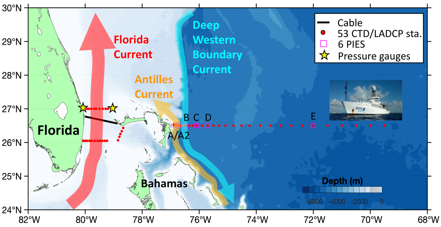
In total, there were 49 CTD casts conducted during the cruise along the 26.5° Abaco line and the 27° and 26° Florida Current lines.
MOCHA/WBTS locations. NOAA image.
There are also 24 Niskin bottles, which are used to collect water samples from individual depths in the water column. This system is connected to the ship by a winch wire with a communication cable that allows us to collect and monitor the data in real time. Using the monitoring software, we are able capture water samples at specific depths in the water column and target specific ocean features. Water samples are collected from each of the Niskin bottles and analyzed onboard the ship to measure the salinity and oxygen levels. These samples and the reference temperature data are considered to be the ground truth and are used to calibrate the CTD sensors.
Ocean currents far below the surface
In addition to the physical water properties measured during the casts, we have a set of instruments called Acoustic Doppler Current Profilers (ADCPs) on the CTD frame which measure ocean current velocity and direction. The ADCP works by transmitting a sound wave in a fixed frequency and listening as it scatters off particles in the ocean.
Based on the Doppler effect, it can then estimate the speed and direction of the water currents using that reflected sound: sound waves reflected off particles that are moving toward the instrument will have a slightly higher frequency then what was transmitted, while sound waves reflected off particles that are moving away from the instrument will have slightly lower frequencies. Using these instruments and the science behind them allows us to measure water currents in the entire water column to depths exceeding 5000m, not just at the surface of the ocean, giving us a more complete picture of what is happening in the global ocean conveyor belt.
Mmm, PIES
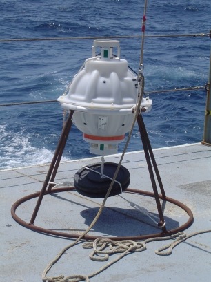
Another aspect of the cruise handled by CIMAS personnel was to operate a series of instruments called Pressure-equipped Inverted Echo Sounder (PIES), an instrument moored to the ocean floor that uses acoustic pings to measure vertical acoustic travel time round-trip from the sea floor to the sea surface. This travel time gives you the average density of the water column above the instrument, which is then used to estimate the water properties present in that water column based on historical data.
PIES mounted in frame. Image from Grant Rawson.
The instruments on the MOCHA/WBTS line are anchored at depths between 1,000 and 5,000m along the 26° 30’ N parallel off the east coast of the Abaco islands, in the Bahamas. There are 6 PIES located along the MOCHA/WBTS line that required acoustic telemetry to recover the data stored on the instruments over 5000m below the surface and 5 of those were also recovered, repaired and redeployed during the cruise to ensure data collection years into the future.